PORTS & HARBORS
City of Saint Paul
Message to Crab Fleet
October 28, 2025
The City of Saint Paul does not currently have a dedicated harbormaster. City staff take turns serving this function. In an effort to assist the crab fleet and reduce the number of calls, the information at right is helpful:
- As boats enter the harbor, the City will still respond to vessels on VHF Channel 16.
- Depending on how many boats come at once they can either go to the TDX/Trident dock or City Dock.
- The City now has security/surveillance cameras in the harbor and can remotely monitor what boats are docked there and can communicate with the boats on which dock to go to.
- TDX stores the crab pots for boats here on the island. Boats needing to pick up their crab pots can contact TDX at 907-546- 4121 or email Chelsea chelseas@tdxcorp.com or Charles jerimiahs@tdxcorp.com with TDX to arrange picking up their pots.
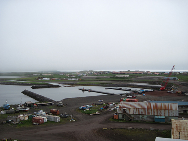
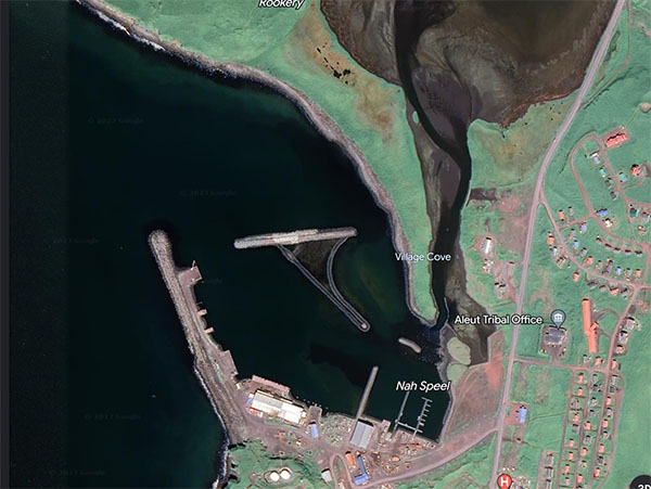
Saint Paul Harbor
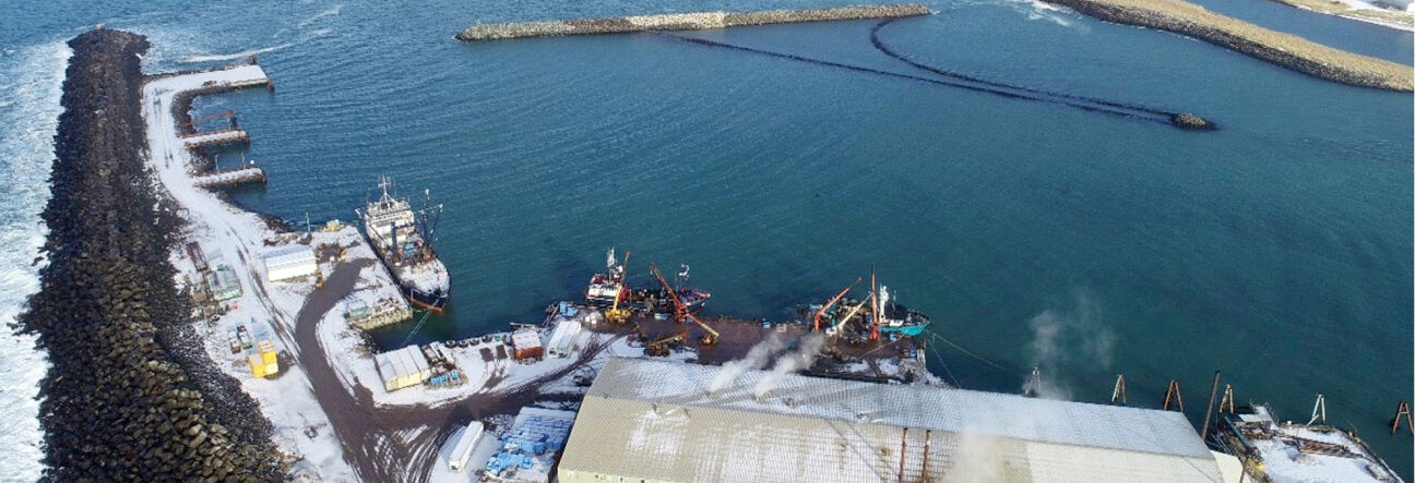
Saint Paul Harbor consists of the main harbor and a small boat harbor. In the main harbor there is the main breakwater and a detached breakwater, the City South and North Docks and Piers, a Harbormaster Office, a barge off-loading area, and a dock and processing plant that is leased to Trident Seafoods. Saint Paul Island is home to the largest crab processing facility in the world, processing 500,000 pounds of crab daily and employing up to 400 workers in peak season. Saint Paul Harbor consists of an outer breakwater and additional wave barrier protecting a three-part moorage basin. Immediately behind the breakwater is the large vessel mooring infrastructure, City South Dock.
Saint Paul Harbor Rates
Dockage, wharfage, and storage in the Saint Paul Harbor are established by City ordinance, see https://saintpaul.municipal.codes/CCO/14.25. The following are the Saint Paul Harbor rates as of January 1, 2025 and do not include tax.
Dockage
| Vessel Length (feet) | Price |
| Minimum – Up to 3 hours | $200.00 — Any time over 3 hours will be billed per 12-hour period |
| Vessels 48′- 100′ in length | $230.60 per 12-hour period |
| Vessels 101′-125′ in length | $286.50 per 12-hour period |
| Vessels 126′-150′ in length | $355.41 per 12-hour period |
| Vessels 151′-175’ in length | $440.23 per 12-hour period |
| Vessels 176′-200′ in length | $496.13 per 12-hour period |
| Vessels 201′-225′ in length | $520.91 per 12-hour period |
| Vessels 226′ + in length | $635.89 per 12-hour period |
| All pleasure vessels | $83.19 per 24-hour period |
Touch & Go
| All vessel classes | $25.00 if vessel is at a City dock less than 15 minutes |
Wharfage
| Loading and Unloading Performed by City | $0.015 per pound |
| Loading and Unloading Performed by Private Party (with Harbormaster approval) | $0.006 per pound |
| Aggregate (e.g. sand, gravel, rock, dredge material) | $1.60 per 2,000 pounds |
Passenger Wharfage Fee
| Upon each visit by a passenger ship docking at a city-owned or city-leased port facility | $12.00 per passenger |
| Upon each visit by a passenger ship that lighters passengers to or from a wharf or port facility owned or leased by the municipality or any private entity | $10.00 per passenger |
| Upon each visit by a passenger ship docking at wharf or port facility owned by a private entity | $8.00 per passenger |
Crab Pots
| Loading or offloading across City docks | $3.06 per pot |
| Repairing/working pots on City docks | $10.44 per pot |
Storage on the Dock
| Authorized use only | $1.38 Per square foot, per day |
| Unauthorized use only | $3.30 Per square foot, per day |
1-Acre Upland Storage
| Authorized use only | $0.23 Per square foot, per day |
Location
The Pribilof Islands
The Saint Paul Harbor is on a narrow peninsula on the southern tip of Saint Paul Island, the largest of the five Pribilof Islands located in the middle of the Bering Sea of Alaska. The extremely remote and rural Saint Paul Island is 47 miles north of the nearest other inhabited Saint George Island, 240 miles north of the Aleutian Islands, 300 miles west of the Alaska mainland, and 750 miles west of Anchorage. The Pribilof Islands are situated on important migration routes for nearly all fish, birds and mammals that populate the rich Bering Sea. The marine infrastructure of Southwest Alaska supports one of the richest fisheries ecosystems in the world. Six of the top ten fishing ports, by value, are in the Southwest Alaska region. Strategically located ports capable of supporting harvesting and processing of fisheries resources are spread across the region, and Saint Paul Island is one of them.
Saint Paul Island
Over the past three decades, U.S. fisheries resourc¬es in the Bering Sea have been managed by the National Marine Fisheries Service (NMFS) to give preferential access and harvest rights to recognized Native Alaskan communities along the Bering Sea coast. Saint Paul Island is one such community. This preferential access has occurred through allocation of 10% of all harvest rights (and if applicable, co-joined processing rights) for all species to these communities through the Western Alaska Community Development Quota (CDQ) Program. An additional effort to provide economic stability in these isolated, Indigenous communities led to crab processing rights being geographically specified to require processing in the Pribilof Islands area. These regional percentages consist of more than 2% of red king crab and over 46% of snow crab allowable harvests. Together with CDQ allocations, the result is that about half of all snow crab harvested in the U.S. is processed in Saint Paul, along with other crab and halibut.
Inner Harbor Facilities
Small Boat Harbor
In 2009 -2010 floating docks were installed in the small boat harbor, which is maintained at a depth of 12 feet MLLW. These provide moorage for the local fleet and are removed seasonally. They are generally designed for vessels 35-feet-long and under. The floating docks are horizontal steel truss framed with polyethylene floatation tubs and a steel grate deck. The main floats are modules that are 14 feet wide and 40 feet long. They are connected to each other with hinges and pins at the ends. There are also seven finger floats that are each 8 feet wide and 36 feet long. These are connected into the center of the main floats at 40-foot spacing. There are no potable water, electricity, fire suppression, or other utilities. There are approximately 15 slips for vessels 35 feet and less in length. In addition, there is about 1000 feet of side-tie moorage available.
City South Dock
The City South dock is a concrete caisson/barge unit that was built by Concrete Technology in Tacoma Washington, towed/floated into position, then set on the bottom and filled with gravel. The as-built drawings are dated 1989. It has a 200-foot-long face and is 40 feet wide. The top has a 6-foot tall by 2-foot-thick parapet at the outer edge / dock face. Behind this is gravel-fill deck surface. There is a fuel header that the city maintains at this dock. There are several concrete-block deadmen chain anchors that have been added to the dock for enhanced mooring line capacity. There are a pair of winches and fairleads, one at each end to aid in mooring the AML barge at the dock.
City North Dock
The City North Dock is a steel H pile supported, steel framed, concrete deck dock. It is 100 feet long and about 53 feet wide. There are three dolphin structures on the north and one on the south. The dolphins are built from steel pipe piles and have tire energy absorbers. The fender consists of rubber cylinders hung along the concrete face by chains.
City Piers 1 & 2
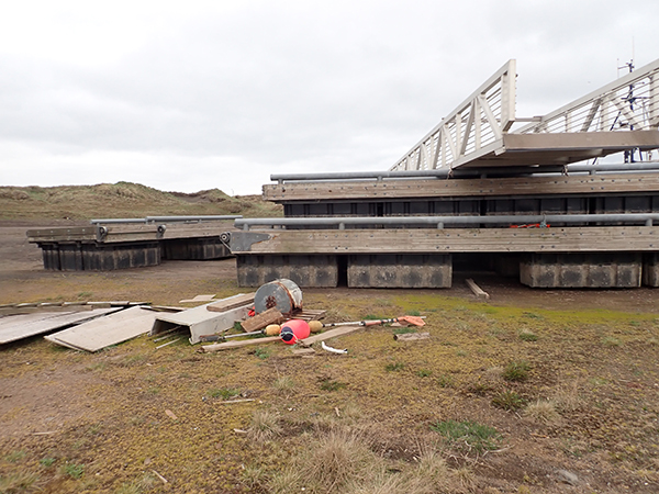
At one point, UniSea had a floating fish processing plant at the site. It has been removed. There are two approach trestles and several deadmen anchors left. Each approach trestle is about 30 feet wide and 70 feet long. Each is steel pipe pile supported with steel framing and a heavy timber deck. Trestles are currently used for temporary moorage; however, they were not designed for this function. They are known locally as City Pier 1 and 2.
Tribal Dock
The Tribal Dock is a steel pipe pile supported, steel framed, timber deck dock. It is 60 feet long and was constructed in 2015. It provides access and support to the vessel repair facility adjacent to the small boat basin.
West Landing
The west landing consists of a concrete bulkhead with a small approach trestle and six dolphins. There are four dolphins on the west and two on the east. Three of the dolphins have tire fenders. The others have no fenders. Each dolphin consists of three steel pipe piles, one vertical and two batters. The approach trestle is 12 feet wide, steel framed, supported by adjacent dolphins, and timber decked. This facility was previously used to moor the Arctic Star, a floating processor for Icicle Seafoods. The processor was removed in the early 2000s. The water depths are too shallow for crab vessel moorage. The facility is not currently used.
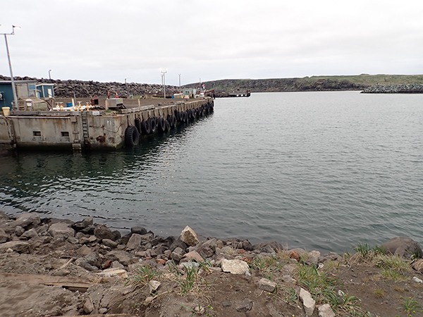
Tanadgusix Corporation/Trident Dock
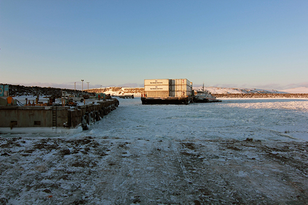
The TDX/Trident Dock was constructed in 1989. It is a steel pile supported, precast concrete deck dock, approximately 294 feet long and 38 feet wide. There are fenders on the face of the dock consisting of steel piling with a timber face panel. The energy is absorbed via side loaded tires that are placed between the upper edge of the face panel and the deck of the dock. There are three pedestal cranes along the face of the dock. These are used to unload seafood product from commercial fishing vessels. There is also a fuel header at this dock that is used to service the Trident fleet as well as all vessels owned by TDX Services. The seafood is loaded into brailers and then lifted from the hold of the vessel onto the dock. From there the brailers are transported to the hoppers on the side of the building for processing. Processed seafood is loaded into refrigerated containers and then transported via commercial barge to the lower 48 states.
Summary of Moorage Facilities
| Facility | Moorage Length | Comments |
| Small Boat Harbor | 15 each 35’ slips 1000’ side tie | Suitable for vessels generally less than 35 feet long. |
| City South Dock | 200’ | The main dock for cargo and fuel barges. Poor wave climate in storm conditions. |
| City North Dock | 100’ | Available in favorable weather conditions only. Often unavailable due to extremely poor wave climate near the end of the breakwater. |
| City Piers 1 & 2 | 2 each at 30’ | Abandoned side tie moorage for floating processor. Used for occasional temporary moorage. |
| Tribal Dock | 60’ | Provides support and access to the vessel repair facility. |
| West Landing | 300’ (approximate) | Abandoned side tie moorage for floating processor. Too shallow for use. |
| TDX/Trident Dock | 294’ | The main dock for crab vessels. Poor wave climate in storm conditions. |
Harbormaster Office
The harbormaster office is currently not staffed or utilized. Its current location, adjacent to the breakwater near the City South Dock, is subject to water damage from waves and spray overtopping the breakwater.
Environmental Conditions
Climate
Saint Paul Island has a northern maritime climate. August is the warmest month with average daily high temperatures of 51.5 degrees Fahrenheit. February is the coldest month with average daily high temperatures of 28.5 degrees Fahrenheit. The highest temperature on record is August 26, 1987 at 66.0 degrees Fahrenheit. The coldest day on record is March 14, 1971 at –19 degrees Fahrenheit.
Precipitation on Saint Paul Island is minimal with an average annual rainfall of about 24 inches. There is some ground snow accumulation in the winter months with annual snowfall averaging 61.7 inches. The island area has periods of persistent and high winds throughout the year. Average year-round winds are 15 MPH. Frequent storms occur from October to April, often accompanied by gale-force winds to produce blizzard conditions.
Tides
| Datum | Elevation (feet) | Notes |
| Max Tide | 5.08 | Observed 12/08/2006 |
| HAT | 4.01 | Highest predicted tide |
| MHHW | 3.24 | |
| MTL | 1.96 | |
| MSL | 1.88 | |
| DTL | 1.62 | |
| MLW | 0.92 | |
| MLLW | 0.00 | |
| LAT | -1.58 | Lowest predicted tide |
| Min Tide | -2.28 | Observed 12/13/1985 |
Waves
There have been studies of the wave climate for the design and construction of the breakwaters. The General Reevaluation Report Environmental Assessment and Finding of No Significant Impact Saint Paul Small Boat Harbor Saint Paul, Alaska February 2006 outlines the following regarding the wave climate:
The existing harbor in Village Cove is in direct alignment with deep-water waves approaching between the west-northwest and southwest sectors. Deep-water waves approaching from the south and southeast sectors are partially sheltered by Saint George Island and Otter Island and would diffract around Reef Point before impinging on the project site. Southerly and southeasterly deep-water waves therefore undergo considerable energy reduction before affecting the project site. Village Cove is in the lee of Saint Paul Island for waves approaching from northwest clockwise through southeast. Waves in the Bering Sea are extremely large, and around the shallower waters of Saint Paul Island, their heights are depth limited during numerous events each year. Maximum wave height to be expected near the entrance to the present harbor is 27 feet.
Wave heights in the present harbor are greatly modified by the breakwaters and spending beaches. Waves are expected to be attenuated to less than three feet by existing protection. Wave energy enters through both the east and west entrances with the dominant energy entering through the west entrance (the navigation channel).
The original 1982 USACE breakwater project was based on a design wave height of 16.5 feet and 9.7 seconds period for a fifty-year storm.
Waves occasionally overtop the existing breakwater. The wave climate in the entrance channel can be extreme, and the harbor is periodically closed due to weather events. The wave climate regularly forces closure of the City North Dock. The inner harbor wave climate has also resulted in broken mooring lines at the City South Dock and at Trident Dock.
Sea Ice
The General Reevaluation Report Environmental Assessment and Finding of No Significant Impact Saint Paul Small Boat Harbor Saint Paul, Alaska February 2006 outlines the following regarding sea ice:
Contact Us
Harbormaster/Harbor Office
The City of Saint Paul does not currently have a dedicated harbormaster. City staff take turns serving this function. As boats enter the harbor, the City will respond on VHF Channel 16.
907-600-4366 (office)
VHF Channel 16
Forms